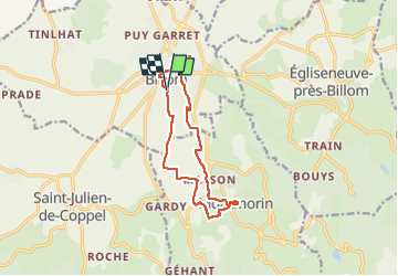
Trail Walking Billom - Billom_Montmorin - Photo
 jagarnier
jagarnier

User GUIDE

© OpenStreetMap contributors
Length
Length
12.6 km
Max alt
Max alt
608 m
Uphill gradient
Uphill gradient
326 m
Km-Effort
Km-Effort  
17 km
Min alt
Min alt
356 m
Downhill gradient
Downhill gradient
329 m
Boucle
Boucle
Yes
Creation date :
2020-07-30 06:55:15.858
Updated on :
2023-03-01 08:40:06.571

(1 Reviews)

Walking
Walking
3h45
Difficulty : Medium

Scan this QR Code to open this trail in the SityTrail application

FREE GPS app for hiking

Logo SityTrail SityTrail

IGN / Geographical institutes

Download SityTrail from the App Store Download SityTrail from Google Play

Logo SityTrail SityTrail Plus

The world is yours!

Download SityTrail from the App Store Download SityTrail from Google Play Download SityTrail on Huawei AppGallery

About

Trail Walking of 12.6 km to be discovered at Auvergne-Rhône-Alpes, Puy-de-Dôme, Billom. This trail is proposed by jagarnier.

Description

Ce circuit vous permettra de découvrir le château de Montmorin et d'admirer de très beaux points de vue, aussi bien à la montée qu' à la descente.
Vous terminerez la randonnées dans les vielles rues du centre médiéval de Billom.

Elevation profile

Photos

Positioning

Country:
France
Region :
Auvergne-Rhône-Alpes
Department/Province :
Puy-de-Dôme
Municipality :
Billom
Location:
Unknown
Start:(UTM)
526422 ; 5062956 (31T) N.

Comments

Please log in to post a review or rate the element


Close
My subscriptions