


30/07/2020

VANDERPUTTENMi
User GUIDE
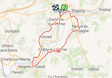

Length
32 km

Max alt
206 m

Uphill gradient
527 m
Km-Effort
39 km

Min alt
55 m

Downhill gradient
526 m
Boucle
Yes
Creation date :
2020-07-30 11:52:28.611
Updated on :
2020-07-30 19:07:24.811
2h48
Difficulty : Very easy

FREE GPS app for hiking
 SityTrail
IGN / Geographical institutes
SityTrail Plus
The world is yours!
About
Trail Mountain bike of 32 km to be discovered at Hauts-de-France, Aisne, Château-Thierry. This trail is proposed by VANDERPUTTENMi.
Description
Difficile dans le bois de Romeny..
Photos

Positioning
Country:
France
Region :
Hauts-de-France
Department/Province :
Aisne
Municipality :
Château-Thierry
Location:
Unknown
Start:(Dec)
Start:(UTM)
527938 ; 5431953 (31U) N.
Comments