


Presles

meillon
User
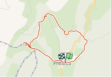

Length
4.8 km

Max alt
1002 m

Uphill gradient
168 m
Km-Effort
7.1 km

Min alt
847 m

Downhill gradient
175 m
Boucle
Yes
Creation date :
2020-07-30 09:08:54.958
Updated on :
2020-07-31 15:02:20.755
3h11
Difficulty : Easy

FREE GPS app for hiking
 SityTrail
IGN / Geographical institutes
SityTrail Plus
The world is yours!
About
Trail Walking of 4.8 km to be discovered at Auvergne-Rhône-Alpes, Isère, Presles. This trail is proposed by meillon.
Positioning
Country:
France
Region :
Auvergne-Rhône-Alpes
Department/Province :
Isère
Municipality :
Presles
Location:
Unknown
Start:(Dec)
Start:(UTM)
687552 ; 4995862 (31T) N.
Comments