


refuge du viso

Martinechampailler
User
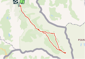

Length
19.8 km

Max alt
2531 m

Uphill gradient
803 m
Km-Effort
30 km

Min alt
1802 m

Downhill gradient
803 m
Boucle
Yes
Creation date :
2020-07-31 05:33:53.034
Updated on :
2020-07-31 17:03:06.557
7h05
Difficulty : Difficult

FREE GPS app for hiking
 SityTrail
IGN / Geographical institutes
SityTrail Plus
The world is yours!
About
Trail Walking of 19.8 km to be discovered at Provence-Alpes-Côte d'Azur, Hautes-Alpes, Abriès-Ristolas. This trail is proposed by Martinechampailler.
Positioning
Country:
France
Region :
Provence-Alpes-Côte d'Azur
Department/Province :
Hautes-Alpes
Municipality :
Abriès-Ristolas
Location:
Ristolas
Start:(Dec)
Start:(UTM)
341485 ; 4955467 (32T) N.
Comments