Trail Walking Ancizan - SityTrail - CAMPAN PAYOLLE le plagnot de Soubirou G3 fait le 31 /07 /2020 - Photo

SityTrail - CAMPAN PAYOLLE le plagnot de Soubirou G3 fait le 31 /07 /2020

 jysc238
jysc238

User

© OpenStreetMap contributors
Length
Length
9.8 km
Max alt
Max alt
1711 m
Uphill gradient
Uphill gradient
480 m
Km-Effort
Km-Effort  
16.2 km
Min alt
Min alt
1248 m
Downhill gradient
Downhill gradient
487 m
Boucle
Boucle
Yes
Creation date :
2020-08-01 11:25:34.461
Updated on :
2020-08-01 11:27:19.098

(0 Reviews)

Walking
Walking
3h19
Difficulty : Difficult

Scan this QR Code to open this trail in the SityTrail application

FREE GPS app for hiking

Logo SityTrail SityTrail

IGN / Geographical institutes

Download SityTrail from the App Store Download SityTrail from Google Play

Logo SityTrail SityTrail World

The world is yours!

Download SityTrail from the App Store Download SityTrail from Google Play Download SityTrail on Huawei AppGallery

About

Trail Walking of 9.8 km to be discovered at Occitania, Hautespyrenees, Ancizan. This trail is proposed by jysc238.

Description

belle balade faite pour la 2eme fois par LPC avec un petit souci JPG repart en ambulance et renseignement pris un problème de desidratation comme quoi ces vieux il faut les faire boire.
un veau en train de mourir un autre veau mort et se faisans dévorer par les vautours. des choses rares en fait mais en direct
on y reviendrea

Elevation profile

Positioning

Country:
France
Region :
Occitania
Department/Province :
Hautespyrenees
Municipality :
Ancizan
Location:
Unknown
Start:(UTM)
279006 ; 4755626 (31T) N.

Trails nearby

Trail Walking Ancizan - Lac d'Arou - Payolle - Photo
Walking
tracegps

Walking

Medium
(4)
Ancizan, Occitania, Hautespyrenees, France
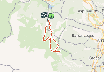
9.8 km | 14.9 km-effort
3h 30min
Yes
Trail Walking Beyrède-Jumet-Camous - Signal de Bassia de Hèche - Photo
Walking
tracegps

Walking

Very difficult
(1)
Beyrède-Jumet-Camous, Occitania, Hautespyrenees, France
3.1 km | 8.2 km-effort
3h 30min
No
Trail On foot Campan - Boucle d'Espiadet - Photo
On foot
PRO

On foot

Easy
Campan, Occitania, Hautespyrenees, France
4.2 km | 6.3 km-effort
1h 25min
No
Trail Walking Ancizan - Soum de Coste Oueillère - Photo
Walking
GUIDE
lhomme.ph

Walking

Difficult
(1)
Ancizan, Occitania, Hautespyrenees, France
9.6 km | 23 km-effort
4h 26min
Yes
Trail Walking Beyrède-Jumet-Camous - Le signal de Bassia depuis le col de Beyrède - Photo
Walking
2033

Walking

Medium
(3)
Beyrède-Jumet-Camous, Occitania, Hautespyrenees, France
4.1 km | 10.3 km-effort
1h 53min
Yes
Trail Walking Campan - Pic de  Bassia, Pic du Castillon, Pic de Paou - Photo
Walking
Prala

Walking

Very easy
(1)
Campan, Occitania, Hautespyrenees, France
10.3 km | 22 km-effort
3h 52min
No
Trail Snowshoes Campan - raquet 1 - Photo
Snowshoes
eliott3

Snowshoes

Easy
(1)
Campan, Occitania, Hautespyrenees, France
4.9 km | 7.2 km-effort
2h 10min
Yes
Trail Walking Campan - payolle - Photo
Walking
yfouldrin

Walking

Very easy
(1)
Campan, Occitania, Hautespyrenees, France
6.5 km | 8.2 km-effort
1h 52min
Yes
Trail Walking Beyrède-Jumet-Camous - Signal de Bassia via le Cap de Paou - Photo
Walking
chrisgps

Walking

Medium
Beyrède-Jumet-Camous, Occitania, Hautespyrenees, France
7.5 km | 15.7 km-effort
3h 33min
Yes


Close
My subscriptions