


Valbonais

peillo
User
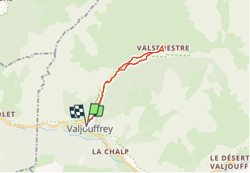

Length
11.5 km

Max alt
1303 m

Uphill gradient
426 m
Km-Effort
17.2 km

Min alt
977 m

Downhill gradient
433 m
Boucle
Yes
Creation date :
2020-08-01 07:34:24.0
Updated on :
2020-08-01 13:40:21.536
3h34
Difficulty : Easy

FREE GPS app for hiking
 SityTrail
IGN / Geographical institutes
SityTrail Plus
The world is yours!
About
Trail Walking of 11.5 km to be discovered at Auvergne-Rhône-Alpes, Isère, Valjouffrey. This trail is proposed by peillo.
Description
Jolie balade tout à l’ombre avec arrivée au gîte possibilité repas bonne tarte
Photos


Positioning
Country:
France
Region :
Auvergne-Rhône-Alpes
Department/Province :
Isère
Municipality :
Valjouffrey
Location:
Unknown
Start:(Dec)
Start:(UTM)
264408 ; 4974135 (32T) N.
Comments