


gorges de la monne

fbienmuller
User
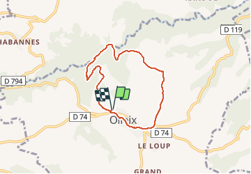

Length
6.4 km

Max alt
866 m

Uphill gradient
187 m
Km-Effort
8.9 km

Min alt
695 m

Downhill gradient
188 m
Boucle
Yes
Creation date :
2020-08-01 11:06:24.718
Updated on :
2020-08-01 14:18:10.663
1h45
Difficulty : Medium

FREE GPS app for hiking
 SityTrail
IGN / Geographical institutes
SityTrail Plus
The world is yours!
About
Trail Walking of 6.4 km to be discovered at Auvergne-Rhône-Alpes, Puy-de-Dôme, Olloix. This trail is proposed by fbienmuller.
Photos


Positioning
Country:
France
Region :
Auvergne-Rhône-Alpes
Department/Province :
Puy-de-Dôme
Municipality :
Olloix
Location:
Unknown
Start:(Dec)
Start:(UTM)
503460 ; 5052179 (31T) N.
Comments
Bonjour, j ai fait les gorges de la Monne et je n ai pas vu ce rocher avec le cœur. Pourriez vous m'indiquer où il se trouve ? Merci