


02/08/2020 - ST JUST Ouest et Sud.Virtuel

babeth35
User
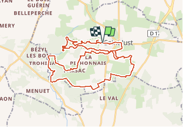

Length
25 km

Max alt
94 m

Uphill gradient
278 m
Km-Effort
28 km

Min alt
16 m

Downhill gradient
279 m
Boucle
Yes
Creation date :
2020-08-02 12:27:36.057
Updated on :
2020-08-02 15:26:13.208
45m
Difficulty : Easy

FREE GPS app for hiking
 SityTrail
IGN / Geographical institutes
SityTrail Plus
The world is yours!
About
Trail Walking of 25 km to be discovered at Brittany, Ille-et-Vilaine, Saint-Just. This trail is proposed by babeth35.
Positioning
Country:
France
Region :
Brittany
Department/Province :
Ille-et-Vilaine
Municipality :
Saint-Just
Location:
Unknown
Start:(Dec)
Start:(UTM)
577061 ; 5290670 (30T) N.
Comments