


2020-08-02 Heidenkirche

Bernardb44
User
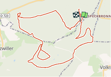

Length
15.3 km

Max alt
391 m

Uphill gradient
408 m
Km-Effort
21 km

Min alt
244 m

Downhill gradient
407 m
Boucle
Yes
Creation date :
2020-08-02 09:15:29.932
Updated on :
2020-08-02 15:23:14.411
5h59
Difficulty : Medium

FREE GPS app for hiking
 SityTrail
IGN / Geographical institutes
SityTrail Plus
The world is yours!
About
Trail Walking of 15.3 km to be discovered at Grand Est, Bas-Rhin, Butten. This trail is proposed by Bernardb44.
Positioning
Country:
France
Region :
Grand Est
Department/Province :
Bas-Rhin
Municipality :
Butten
Location:
Unknown
Start:(Dec)
Start:(UTM)
374327 ; 5424841 (32U) N.
Comments