


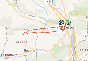
SISTERON. Le Mollard . Col S Pierre o n

RobinMicheline
User GUIDE

Length
11.9 km

Max alt
915 m

Uphill gradient
514 m
Km-Effort
18.7 km

Min alt
504 m

Downhill gradient
516 m
Boucle
Yes
Creation date :
2020-08-03 05:42:55.913
Updated on :
2020-08-03 14:03:55.982
2h58
Difficulty : Medium

FREE GPS app for hiking
 SityTrail
IGN / Geographical institutes
SityTrail Plus
The world is yours!
About
Trail Walking of 11.9 km to be discovered at Provence-Alpes-Côte d'Azur, Alpes-de-Haute-Provence, Sisteron. This trail is proposed by RobinMicheline.
Description
Sentier Cretes sympa belle vue , descente avant col S Pierre raide ne pas faire si pluie
Photos


Positioning
Country:
France
Region :
Provence-Alpes-Côte d'Azur
Department/Province :
Alpes-de-Haute-Provence
Municipality :
Sisteron
Location:
Unknown
Start:(Dec)
Start:(UTM)
735044 ; 4897775 (31T) N.
Comments