


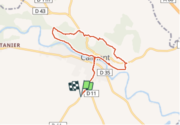
Les coteaux de Calmont

richardsimopons
User

Length
8.4 km

Max alt
310 m

Uphill gradient
148 m
Km-Effort
10.4 km

Min alt
209 m

Downhill gradient
149 m
Boucle
Yes
Creation date :
2020-08-03 06:53:52.0
Updated on :
2020-08-03 09:30:17.248
2h28
Difficulty : Unknown

FREE GPS app for hiking
 SityTrail
IGN / Geographical institutes
SityTrail Plus
The world is yours!
About
Trail Walking of 8.4 km to be discovered at Occitania, Haute-Garonne, Calmont. This trail is proposed by richardsimopons.
Description
Home CS, les Moines, Guerri
er, Galinat, Toumboroussy, Paillole, Route de Faou, centre, Home CS.
Photos


Positioning
Country:
France
Region :
Occitania
Department/Province :
Haute-Garonne
Municipality :
Calmont
Location:
Unknown
Start:(Dec)
Start:(UTM)
388718 ; 4792498 (31T) N.
Comments