


Bouderont agneux

ash
User
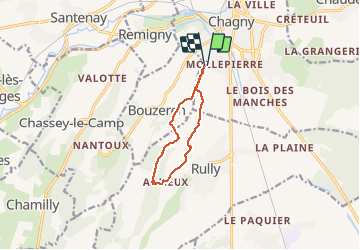

Length
8.3 km

Max alt
365 m

Uphill gradient
224 m
Km-Effort
11.3 km

Min alt
228 m

Downhill gradient
224 m
Boucle
Yes
Creation date :
2020-08-04 06:58:08.0
Updated on :
2020-08-04 09:05:59.457
1h53
Difficulty : Very easy

FREE GPS app for hiking
 SityTrail
IGN / Geographical institutes
SityTrail Plus
The world is yours!
About
Trail Walking of 8.3 km to be discovered at Bourgogne-Franche-Comté, Saône-et-Loire, Chagny. This trail is proposed by ash.
Positioning
Country:
France
Region :
Bourgogne-Franche-Comté
Department/Province :
Saône-et-Loire
Municipality :
Chagny
Location:
Unknown
Start:(Dec)
Start:(UTM)
632831 ; 5195526 (31T) N.
Comments