


Dramont

aljac
User
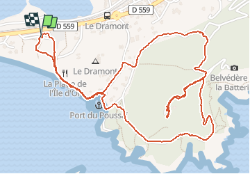

Length
3.9 km

Max alt
117 m

Uphill gradient
138 m
Km-Effort
5.8 km

Min alt
1 m

Downhill gradient
138 m
Boucle
Yes
Creation date :
2020-08-04 08:41:56.852
Updated on :
2020-08-04 10:05:06.099
1h22
Difficulty : Very easy

FREE GPS app for hiking
 SityTrail
IGN / Geographical institutes
SityTrail Plus
The world is yours!
About
Trail Walking of 3.9 km to be discovered at Provence-Alpes-Côte d'Azur, Var, Saint-Raphaël. This trail is proposed by aljac.
Positioning
Country:
France
Region :
Provence-Alpes-Côte d'Azur
Department/Province :
Var
Municipality :
Saint-Raphaël
Location:
Unknown
Start:(Dec)
Start:(UTM)
325506 ; 4809418 (32T) N.
Comments