


originale mais caillouteuse chaynat

bendoush
User
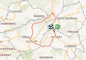

Length
12.4 km

Max alt
797 m

Uphill gradient
316 m
Km-Effort
16.7 km

Min alt
517 m

Downhill gradient
317 m
Boucle
Yes
Creation date :
2020-08-04 12:05:29.764
Updated on :
2020-08-04 15:34:07.931
3h27
Difficulty : Medium

FREE GPS app for hiking
 SityTrail
IGN / Geographical institutes
SityTrail Plus
The world is yours!
About
Trail Walking of 12.4 km to be discovered at Auvergne-Rhône-Alpes, Puy-de-Dôme, Ludesse. This trail is proposed by bendoush.
Positioning
Country:
France
Region :
Auvergne-Rhône-Alpes
Department/Province :
Puy-de-Dôme
Municipality :
Ludesse
Location:
Unknown
Start:(Dec)
Start:(UTM)
506864 ; 5052514 (31T) N.
Comments