


La Haute Loge

DD88
User
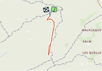

Length
8.8 km

Max alt
903 m

Uphill gradient
269 m
Km-Effort
12.4 km

Min alt
768 m

Downhill gradient
270 m
Boucle
Yes
Creation date :
2020-07-12 13:09:20.0
Updated on :
2020-08-04 19:06:48.325
2h45
Difficulty : Easy

FREE GPS app for hiking
 SityTrail
IGN / Geographical institutes
SityTrail Plus
The world is yours!
About
Trail Walking of 8.8 km to be discovered at Grand Est, Vosges, Moussey. This trail is proposed by DD88.
Description
La Haute Loge
Positioning
Country:
France
Region :
Grand Est
Department/Province :
Vosges
Municipality :
Moussey
Location:
Unknown
Start:(Dec)
Start:(UTM)
359889 ; 5371208 (32U) N.
Comments