


Raccourci Laurence allee des Colombes

jmheydorff
User
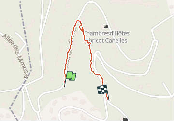

Length
639 m

Max alt
152 m

Uphill gradient
0 m
Km-Effort
752 m

Min alt
115 m

Downhill gradient
34 m
Boucle
Yes
Creation date :
2020-08-05 04:52:16.0
Updated on :
2020-08-05 05:03:44.597
10m
Difficulty : Very easy

FREE GPS app for hiking
 SityTrail
IGN / Geographical institutes
SityTrail Plus
The world is yours!
About
Trail Walking of 639 m to be discovered at Provence-Alpes-Côte d'Azur, Var, Hyères. This trail is proposed by jmheydorff.
Positioning
Country:
France
Region :
Provence-Alpes-Côte d'Azur
Department/Province :
Var
Municipality :
Hyères
Location:
Unknown
Start:(Dec)
Start:(UTM)
264659 ; 4774920 (32T) N.
Comments