Trail Other activity Perrefitte - Montagne de Moutier - Photo
 rebetez
rebetez

User

© OpenStreetMap contributors
Length
Length
11 km
Max alt
Max alt
1155 m
Uphill gradient
Uphill gradient
507 m
Km-Effort
Km-Effort  
17.8 km
Min alt
Min alt
729 m
Downhill gradient
Downhill gradient
507 m
Boucle
Boucle
Yes
Creation date :
2014-12-11 00:00:00.0
Updated on :
2014-12-11 00:00:00.0

(0 Reviews)

Other activity
Other activity
--
Difficulty : Unknown

Scan this QR Code to open this trail in the SityTrail application

FREE GPS app for hiking

Logo SityTrail SityTrail

IGN / Geographical institutes

Download SityTrail from the App Store Download SityTrail from Google Play

Logo SityTrail SityTrail World

The world is yours!

Download SityTrail from the App Store Download SityTrail from Google Play Download SityTrail on Huawei AppGallery

About

Trail Other activity of 11 km to be discovered at Bern, Bernese Jura administrative district, Perrefitte. This trail is proposed by rebetez.

Description

Haute Montagne de Moutier via le Coulou et la Crête

Elevation profile

Positioning

Country:
Switzerland
Region :
Bern
Department/Province :
Bernese Jura administrative district
Municipality :
Perrefitte
Location:
Unknown
Start:(UTM)
372619 ; 5237115 (32T) N.

Trails nearby

Trail On foot Courrendlin - Vellerat - fixme - Photo
On foot
GUIDE+

On foot

Easy
Courrendlin, Jura, District de Delémont, Switzerland
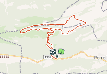
4.5 km | 8.2 km-effort
1h 51min
No
Trail On foot Courrendlin - Vellerat - La Combe - Photo
On foot
GUIDE+

On foot

Easy
Courrendlin, Jura, District de Delémont, Switzerland
5.3 km | 9.7 km-effort
2h 12min
No
Trail On foot Moutier - Montagne de Moutier - Pré La Vigne - Photo
On foot
GUIDE+

On foot

Easy
Moutier, Bern, Bernese Jura administrative district, Switzerland
3.8 km | 4.9 km-effort
1h 7min
No
Trail On foot Haute-Sorne - Soulce - fixme - Photo
On foot
GUIDE+

On foot

Easy
Haute-Sorne, Jura, District de Delémont, Switzerland
3.3 km | 7.5 km-effort
1h 41min
No
Trail On foot Roches (BE) - La Combe - Les Fouchies - Photo
On foot
GUIDE+

On foot

Easy
Roches (BE), Bern, Bernese Jura administrative district, Switzerland
3.9 km | 5.2 km-effort
1h 10min
No
Trail On foot Haute-Sorne - Les Fouchies - fixme - Photo
On foot
GUIDE+

On foot

Easy
Haute-Sorne, Jura, District de Delémont, Switzerland
4.9 km | 6.3 km-effort
1h 25min
No
Trail On foot Haute-Sorne - Pré La Vigne - fixme - Photo
On foot
GUIDE+

On foot

Easy
Haute-Sorne, Jura, District de Delémont, Switzerland
3.6 km | 4.6 km-effort
1h 3min
No
Trail On foot Haute-Sorne - Pré La Vigne - Soulce - Photo
On foot
GUIDE+

On foot

Easy
Haute-Sorne, Jura, District de Delémont, Switzerland
3.8 km | 5.5 km-effort
1h 15min
No
Trail On foot Haute-Sorne - Pré La Vigne - Sur la Côte - Photo
On foot
GUIDE+

On foot

Easy
Haute-Sorne, Jura, District de Delémont, Switzerland
4.5 km | 5.8 km-effort
1h 19min
No


Close
My subscriptions