


Val

cmike39
User
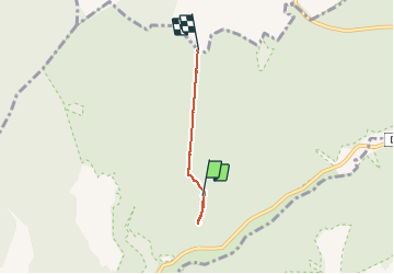

Length
2.6 km

Max alt
556 m

Uphill gradient
88 m
Km-Effort
3.6 km

Min alt
455 m

Downhill gradient
37 m
Boucle
No
Creation date :
2020-08-06 15:49:06.767
Updated on :
2020-08-06 16:53:31.065
51m
Difficulty : Very easy

FREE GPS app for hiking
 SityTrail
IGN / Geographical institutes
SityTrail Plus
The world is yours!
About
Trail Walking of 2.6 km to be discovered at Bourgogne-Franche-Comté, Côte-d'Or, Val-Suzon. This trail is proposed by cmike39.
Positioning
Country:
France
Region :
Bourgogne-Franche-Comté
Department/Province :
Côte-d'Or
Municipality :
Val-Suzon
Location:
Unknown
Start:(Dec)
Start:(UTM)
644588 ; 5254151 (31T) N.
Comments