


Fond de la Rivière

YCDBSOYA
User
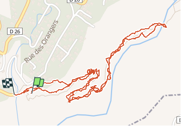

Length
3.1 km

Max alt
431 m

Uphill gradient
213 m
Km-Effort
6 km

Min alt
233 m

Downhill gradient
219 m
Boucle
Yes
Creation date :
2020-08-07 05:47:44.0
Updated on :
2020-08-07 07:32:18.698
1h22
Difficulty : Easy

FREE GPS app for hiking
 SityTrail
IGN / Geographical institutes
SityTrail Plus
The world is yours!
About
Trail Walking of 3.1 km to be discovered at Réunion, Unknown, Entre-Deux. This trail is proposed by YCDBSOYA.
Description
Descente à l’entre deux vers le bras de la plaine
Positioning
Country:
France
Region :
Réunion
Department/Province :
Unknown
Municipality :
Entre-Deux
Location:
Unknown
Start:(Dec)
Start:(UTM)
341962 ; 7649210 (40K) S.
Comments