


Ancien Canal du Verdon - Aqueduc de Parrouvier - Torrent du Lauvas

Nathy8913
User
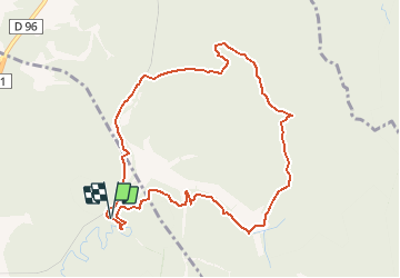

Length
10 km

Max alt
457 m

Uphill gradient
241 m
Km-Effort
13.3 km

Min alt
282 m

Downhill gradient
245 m
Boucle
Yes
Creation date :
2020-08-07 12:25:23.727
Updated on :
2020-08-07 12:25:33.57

FREE GPS app for hiking
 SityTrail
IGN / Geographical institutes
SityTrail Plus
The world is yours!
About
Trail of 10 km to be discovered at Provence-Alpes-Côte d'Azur, Bouches-du-Rhône, Venelles. This trail is proposed by Nathy8913.
Points of interest


Positioning
Country:
France
Region :
Provence-Alpes-Côte d'Azur
Department/Province :
Bouches-du-Rhône
Municipality :
Venelles
Location:
Unknown
Start:(Dec)
Start:(UTM)
703049 ; 4829666 (31T) N.
Comments