20200807

Yanitch
User

Length
8.7 km

Max alt
1324 m

Uphill gradient
293 m
Km-Effort
12.6 km

Min alt
1086 m

Downhill gradient
302 m
Boucle
Yes
Creation date :
2020-08-07 08:30:03.841
Updated on :
2020-08-07 12:53:53.949
4h23
Difficulty : Very easy

FREE GPS app for hiking
 SityTrail
IGN / Geographical institutes
SityTrail Plus
The world is yours!
About
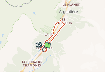
Trail Walking of 8.7 km to be discovered at Auvergne-Rhône-Alpes, Upper Savoy, Chamonix-Mont-Blanc. This trail is proposed by Yanitch.
Positioning
Country:
France
Region :
Auvergne-Rhône-Alpes
Department/Province :
Upper Savoy
Municipality :
Chamonix-Mont-Blanc
Location:
Unknown
Start:(Dec)
Start:(UTM)
337286 ; 5090687 (32T) N.
Comments