


jour 1 rando Ski 2014

norbertmarteau
User
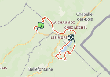

Length
12.6 km

Max alt
1176 m

Uphill gradient
294 m
Km-Effort
16.4 km

Min alt
1081 m

Downhill gradient
243 m
Boucle
No
Creation date :
2014-12-10 00:00:00.0
Updated on :
2014-12-10 00:00:00.0
3h16
Difficulty : Easy

FREE GPS app for hiking
 SityTrail
IGN / Geographical institutes
SityTrail Plus
The world is yours!
About
Trail Winter sports of 12.6 km to be discovered at Bourgogne-Franche-Comté, Jura, Morbier. This trail is proposed by norbertmarteau.
Positioning
Country:
France
Region :
Bourgogne-Franche-Comté
Department/Province :
Jura
Municipality :
Morbier
Location:
Unknown
Start:(Dec)
Start:(UTM)
274818 ; 5163351 (32T) N.
Comments