


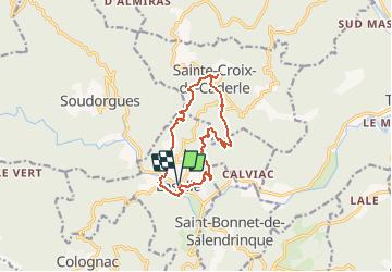
Gard - Lasalle Ste-Ctoix-de-Caderle 11km 370m

RandoVal
User

Length
11.7 km

Max alt
599 m

Uphill gradient
432 m
Km-Effort
17.4 km

Min alt
278 m

Downhill gradient
434 m
Boucle
Yes
Creation date :
2020-08-09 06:35:07.102
Updated on :
2020-08-10 11:26:10.392
--
Difficulty : Unknown

FREE GPS app for hiking
 SityTrail
IGN / Geographical institutes
SityTrail Plus
The world is yours!
About
Trail Walking of 11.7 km to be discovered at Occitania, Gard, Lasalle. This trail is proposed by RandoVal.
Description
Boucle en Cévennes gardoise, départ et stationnement place de la mairie de Lasalle, sens anti-horaire. Beau point de vue à Ste-Croix-de-Caderle.
Positioning
Country:
France
Region :
Occitania
Department/Province :
Gard
Municipality :
Lasalle
Location:
Unknown
Start:(Dec)
Start:(UTM)
568453 ; 4877257 (31T) N.
Comments