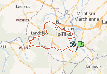
Montigny rue de la Station -Abbaye Aulne - LANDEL

pjennes
User

Length
13.5 km

Max alt
206 m

Uphill gradient
215 m
Km-Effort
16.3 km

Min alt
106 m

Downhill gradient
214 m
Boucle
Yes
Creation date :
2020-08-09 06:11:12.0
Updated on :
2020-08-09 09:25:45.967
2h51
Difficulty : Medium

FREE GPS app for hiking
 SityTrail
IGN / Geographical institutes
SityTrail Plus
The world is yours!
About
Trail Walking of 13.5 km to be discovered at Wallonia, Hainaut, Montigny-le-Tilleul. This trail is proposed by pjennes.
Description
De la rue de la Station à Landelies à la rue de ja station par Aulne à l’aller et le Chemin TAVERNEL au retour
Positioning
Country:
Belgium
Region :
Wallonia
Department/Province :
Hainaut
Municipality :
Montigny-le-Tilleul
Location:
Montignies-le-Tilleul
Start:(Dec)
Start:(UTM)
599076 ; 5580075 (31U) N.
Comments