


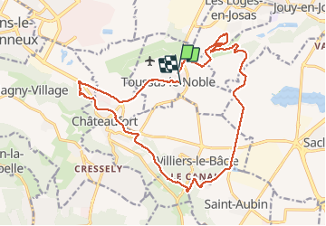
Toussus le Noble

pmauvieux
User

Length
19.2 km

Max alt
163 m

Uphill gradient
215 m
Km-Effort
22 km

Min alt
90 m

Downhill gradient
214 m
Boucle
No
Creation date :
2020-08-09 05:53:45.521
Updated on :
2020-08-09 10:14:06.569
4h18
Difficulty : Very easy

FREE GPS app for hiking
 SityTrail
IGN / Geographical institutes
SityTrail Plus
The world is yours!
About
Trail Walking of 19.2 km to be discovered at Ile-de-France, Yvelines, Toussus-le-Noble. This trail is proposed by pmauvieux.
Positioning
Country:
France
Region :
Ile-de-France
Department/Province :
Yvelines
Municipality :
Toussus-le-Noble
Location:
Unknown
Start:(Dec)
Start:(UTM)
435183 ; 5399801 (31U) N.
Comments