


Bachtel

DonatEnz
User

Length
8.5 km

Max alt
1126 m

Uphill gradient
564 m
Km-Effort
15.9 km

Min alt
567 m

Downhill gradient
514 m
Boucle
No
Creation date :
2014-12-11 00:00:00.0
Updated on :
2014-12-11 00:00:00.0
--
Difficulty : Unknown

FREE GPS app for hiking
 SityTrail
IGN / Geographical institutes
SityTrail Plus
The world is yours!
About
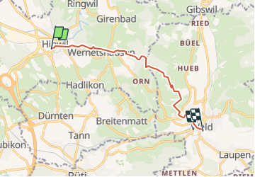
Trail Other activity of 8.5 km to be discovered at Zurich, Bezirk Hinwil, Hinwil. This trail is proposed by DonatEnz.
Description
Von Hinwil nach Wald
Positioning
Country:
Switzerland
Region :
Zurich
Department/Province :
Bezirk Hinwil
Municipality :
Hinwil
Location:
Unknown
Start:(Dec)
Start:(UTM)
487920 ; 5238478 (32T) N.
Comments