


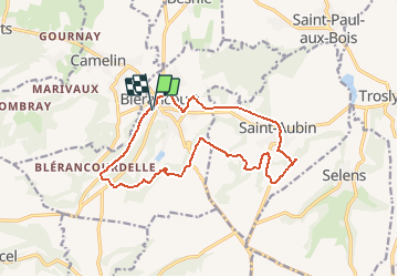
Blérancourt

fitz2014
User

Length
14.1 km

Max alt
135 m

Uphill gradient
235 m
Km-Effort
17.2 km

Min alt
60 m

Downhill gradient
235 m
Boucle
Yes
Creation date :
2020-08-10 10:41:36.556
Updated on :
2020-08-11 11:02:55.197
3h42
Difficulty : Difficult

FREE GPS app for hiking
 SityTrail
IGN / Geographical institutes
SityTrail Plus
The world is yours!
About
Trail Walking of 14.1 km to be discovered at Hauts-de-France, Aisne, Blérancourt. This trail is proposed by fitz2014.
Description
Parcours avec un bon dénivelé, attention aux horaires du musée afin de pouvoir le traverser, sinon il faudra faire un détour.
Positioning
Country:
France
Region :
Hauts-de-France
Department/Province :
Aisne
Municipality :
Blérancourt
Location:
Unknown
Start:(Dec)
Start:(UTM)
510870 ; 5484710 (31U) N.
Comments