


Les Borrys La Tapi

jymrando
User
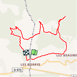

Length
11.2 km

Max alt
292 m

Uphill gradient
254 m
Km-Effort
14.6 km

Min alt
151 m

Downhill gradient
255 m
Boucle
Yes
Creation date :
2014-12-10 00:00:00.0
Updated on :
2014-12-10 00:00:00.0
3h10
Difficulty : Easy

FREE GPS app for hiking
 SityTrail
IGN / Geographical institutes
SityTrail Plus
The world is yours!
About
Trail Walking of 11.2 km to be discovered at Provence-Alpes-Côte d'Azur, Vaucluse, Puget. This trail is proposed by jymrando.
Description
Agréable tour en collines, mais un peu de route au départ, et aller retour à La Tapi un peu long.
Positioning
Country:
France
Region :
Provence-Alpes-Côte d'Azur
Department/Province :
Vaucluse
Municipality :
Puget
Location:
Unknown
Start:(Dec)
Start:(UTM)
679971 ; 4847529 (31T) N.
Comments