


Les gorges de la languettes et de malvaux

ash
User
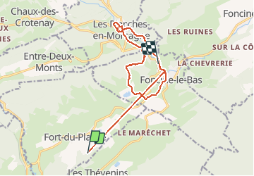

Length
14.9 km

Max alt
916 m

Uphill gradient
354 m
Km-Effort
19.9 km

Min alt
697 m

Downhill gradient
450 m
Boucle
No
Creation date :
2020-08-11 06:51:44.0
Updated on :
2020-08-11 10:08:40.515
2h45
Difficulty : Easy

FREE GPS app for hiking
 SityTrail
IGN / Geographical institutes
SityTrail Plus
The world is yours!
About
Trail Walking of 14.9 km to be discovered at Bourgogne-Franche-Comté, Jura, Fort-du-Plasne. This trail is proposed by ash.
Description
PR28
Photos


Positioning
Country:
France
Region :
Bourgogne-Franche-Comté
Department/Province :
Jura
Municipality :
Fort-du-Plasne
Location:
Unknown
Start:(Dec)
Start:(UTM)
729103 ; 5166469 (31T) N.
Comments