


23/03/2019.Corrigé - CARENTOIR nord-ouest

babeth35
User

Length
31 km

Max alt
115 m

Uphill gradient
456 m
Km-Effort
37 km

Min alt
27 m

Downhill gradient
466 m
Boucle
Yes
Creation date :
2019-03-29 13:29:29.238
Updated on :
2020-08-11 13:06:58.909
--
Difficulty : Medium
8h11
Difficulty : Medium

FREE GPS app for hiking
 SityTrail
IGN / Geographical institutes
SityTrail Plus
The world is yours!
About
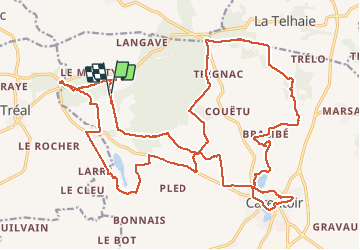
Trail On foot of 31 km to be discovered at Brittany, Morbihan, Carentoir. This trail is proposed by babeth35.
Photos


Positioning
Country:
France
Region :
Brittany
Department/Province :
Morbihan
Municipality :
Carentoir
Location:
Carentoir
Start:(Dec)
Start:(UTM)
560549 ; 5299067 (30T) N.
Comments