


Ent20200813

Valery01
User

Length
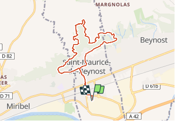
8.9 km

Max alt
309 m

Uphill gradient
169 m
Km-Effort
11.2 km

Min alt
177 m

Downhill gradient
170 m
Boucle
Yes
Creation date :
2020-08-13 09:50:56.0
Updated on :
2020-08-13 10:54:57.447
1h04
Difficulty : Unknown

FREE GPS app for hiking
 SityTrail
IGN / Geographical institutes
SityTrail Plus
The world is yours!
About
Trail Trail of 8.9 km to be discovered at Auvergne-Rhône-Alpes, Ain, Saint-Maurice-de-Beynost. This trail is proposed by Valery01.
Positioning
Country:
France
Region :
Auvergne-Rhône-Alpes
Department/Province :
Ain
Municipality :
Saint-Maurice-de-Beynost
Location:
Unknown
Start:(Dec)
Start:(UTM)
653731 ; 5076522 (31T) N.
Comments