


Colmars - Le laupon

soca
User
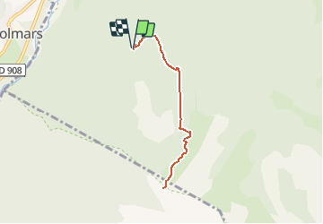

Length
6.9 km

Max alt
2423 m

Uphill gradient
711 m
Km-Effort
16.4 km

Min alt
1705 m

Downhill gradient
712 m
Boucle
Yes
Creation date :
2020-08-13 15:59:25.698
Updated on :
2020-08-13 16:04:13.699
3h11
Difficulty : Difficult

FREE GPS app for hiking
 SityTrail
IGN / Geographical institutes
SityTrail Plus
The world is yours!
About
Trail Walking of 6.9 km to be discovered at Provence-Alpes-Côte d'Azur, Alpes-de-Haute-Provence, Colmars. This trail is proposed by soca.
Positioning
Country:
France
Region :
Provence-Alpes-Côte d'Azur
Department/Province :
Alpes-de-Haute-Provence
Municipality :
Colmars
Location:
Unknown
Start:(Dec)
Start:(UTM)
310511 ; 4892802 (32T) N.
Comments