


plan de l'aar du jaillet

olivieraron
User
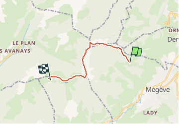

Length
7.3 km

Max alt
1842 m

Uphill gradient
440 m
Km-Effort
12.6 km

Min alt
1582 m

Downhill gradient
277 m
Boucle
No
Creation date :
2020-08-13 16:22:51.571
Updated on :
2020-08-13 16:30:04.975
2h39
Difficulty : Medium

FREE GPS app for hiking
 SityTrail
IGN / Geographical institutes
SityTrail Plus
The world is yours!
About
Trail Walking of 7.3 km to be discovered at Auvergne-Rhône-Alpes, Upper Savoy, Megève. This trail is proposed by olivieraron.
Positioning
Country:
France
Region :
Auvergne-Rhône-Alpes
Department/Province :
Upper Savoy
Municipality :
Megève
Location:
Unknown
Start:(Dec)
Start:(UTM)
313634 ; 5082363 (32T) N.
Comments