


la tour des poignets depuis la croix de Beauzon

MCARY
User
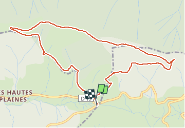

Length
6 km

Max alt
1526 m

Uphill gradient
244 m
Km-Effort
9.3 km

Min alt
1306 m

Downhill gradient
248 m
Boucle
Yes
Creation date :
2020-08-14 03:56:40.251
Updated on :
2020-11-28 10:37:58.773
1h27
Difficulty : Medium

FREE GPS app for hiking
 SityTrail
IGN / Geographical institutes
SityTrail Plus
The world is yours!
About
Trail Walking of 6 km to be discovered at Auvergne-Rhône-Alpes, Ardèche, Mayres. This trail is proposed by MCARY.
Positioning
Country:
France
Region :
Auvergne-Rhône-Alpes
Department/Province :
Ardèche
Municipality :
Mayres
Location:
Unknown
Start:(Dec)
Start:(UTM)
587012 ; 4943053 (31T) N.
Comments