


randogps12-291

tercla
User
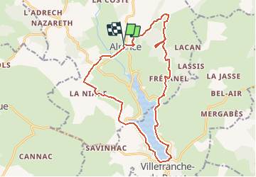

Length
18.4 km

Max alt
908 m

Uphill gradient
380 m
Km-Effort
23 km

Min alt
714 m

Downhill gradient
375 m
Boucle
Yes
Creation date :
2020-08-14 10:01:44.511
Updated on :
2020-08-14 10:08:08.121
--
Difficulty : Easy

FREE GPS app for hiking
 SityTrail
IGN / Geographical institutes
SityTrail Plus
The world is yours!
About
Trail On foot of 18.4 km to be discovered at Occitania, Aveyron, Alrance. This trail is proposed by tercla.
Positioning
Country:
France
Region :
Occitania
Department/Province :
Aveyron
Municipality :
Alrance
Location:
Unknown
Start:(Dec)
Start:(UTM)
474628 ; 4886534 (31T) N.
Comments