


olivieraron
User
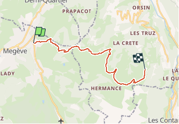

Length
11.1 km

Max alt
2001 m

Uphill gradient
994 m
Km-Effort
23 km

Min alt
1265 m

Downhill gradient
588 m
Boucle
No
Creation date :
2020-08-14 15:34:35.578
Updated on :
2020-08-14 15:34:35.578

FREE GPS app for hiking
 SityTrail
IGN / Geographical institutes
SityTrail Plus
The world is yours!
About
Trail of 11.1 km to be discovered at Auvergne-Rhône-Alpes, Upper Savoy, Megève. This trail is proposed by olivieraron.
Positioning
Country:
France
Region :
Auvergne-Rhône-Alpes
Department/Province :
Upper Savoy
Municipality :
Megève
Location:
Unknown
Start:(Dec)
Start:(UTM)
316090 ; 5081265 (32T) N.
Comments