


Anost N°3

xst
User
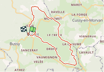

Length
19.4 km

Max alt
680 m

Uphill gradient
574 m
Km-Effort
27 km

Min alt
370 m

Downhill gradient
568 m
Boucle
Yes
Creation date :
2020-08-14 12:42:50.081
Updated on :
2020-08-15 08:27:35.562
2h13
Difficulty : Difficult

FREE GPS app for hiking
 SityTrail
IGN / Geographical institutes
SityTrail Plus
The world is yours!
About
Trail Mountain bike of 19.4 km to be discovered at Bourgogne-Franche-Comté, Saône-et-Loire, Anost. This trail is proposed by xst.
Description
rando physique. petit cafouillage au début. très agréable, beau paysage.
Positioning
Country:
France
Region :
Bourgogne-Franche-Comté
Department/Province :
Saône-et-Loire
Municipality :
Anost
Location:
Unknown
Start:(Dec)
Start:(UTM)
582973 ; 5214225 (31T) N.
Comments