


Monthiers

fitz2014
User
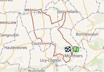

Length
17.7 km

Max alt
182 m

Uphill gradient
295 m
Km-Effort
22 km

Min alt
92 m

Downhill gradient
292 m
Boucle
Yes
Creation date :
2020-08-15 10:26:29.625
Updated on :
2020-08-15 11:08:11.345
3h57
Difficulty : Difficult

FREE GPS app for hiking
 SityTrail
IGN / Geographical institutes
SityTrail Plus
The world is yours!
About
Trail Walking of 17.7 km to be discovered at Hauts-de-France, Aisne, Monthiers. This trail is proposed by fitz2014.
Positioning
Country:
France
Region :
Hauts-de-France
Department/Province :
Aisne
Municipality :
Monthiers
Location:
Unknown
Start:(Dec)
Start:(UTM)
521828 ; 5438964 (31U) N.
Comments