Rand'eau dans le Toulourenc

dejongm
User
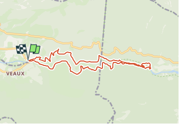

Length
9.6 km

Max alt
517 m

Uphill gradient
340 m
Km-Effort
14.1 km

Min alt
319 m

Downhill gradient
340 m
Boucle
Yes
Creation date :
2020-08-15 13:00:33.755
Updated on :
2024-08-06 07:30:05.429
3h12
Difficulty : Difficult

FREE GPS app for hiking
 SityTrail
IGN / Geographical institutes
SityTrail Plus
The world is yours!
About
Trail Walking of 9.6 km to be discovered at Auvergne-Rhône-Alpes, Drôme, Mollans-sur-Ouvèze. This trail is proposed by dejongm.
Positioning
Country:
France
Region :
Auvergne-Rhône-Alpes
Department/Province :
Drôme
Municipality :
Mollans-sur-Ouvèze
Location:
Unknown
Start:(Dec)
Start:(UTM)
676821 ; 4898164 (31T) N.
Comments