


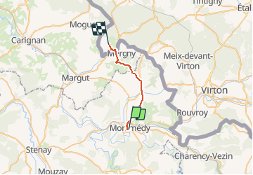
La Transgaumaise, étape 3, Montmédy - Orval

seghth
User

Length
18.4 km

Max alt
329 m

Uphill gradient
387 m
Km-Effort
24 km

Min alt
191 m

Downhill gradient
386 m
Boucle
No
Creation date :
2020-08-15 09:13:59.815
Updated on :
2020-08-16 08:38:41.86
5h00
Difficulty : Very easy

FREE GPS app for hiking
 SityTrail
IGN / Geographical institutes
SityTrail Plus
The world is yours!
About
Trail Walking of 18.4 km to be discovered at Grand Est, Meuse, Montmédy. This trail is proposed by seghth.
Description
Jusque Ferme de Bois le Comte à Villers devant Orval
Positioning
Country:
France
Region :
Grand Est
Department/Province :
Meuse
Municipality :
Montmédy
Location:
Unknown
Start:(Dec)
Start:(UTM)
671197 ; 5487758 (31U) N.
Comments