


rando pourrie Châlons sur Saône

bendoush
User

Length
9.8 km

Max alt
231 m

Uphill gradient
97 m
Km-Effort
11 km

Min alt
197 m

Downhill gradient
94 m
Boucle
Yes
Creation date :
2020-08-15 10:48:16.713
Updated on :
2020-08-16 11:33:58.993
2h44
Difficulty : Easy

FREE GPS app for hiking
 SityTrail
IGN / Geographical institutes
SityTrail Plus
The world is yours!
About
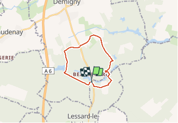
Trail Walking of 9.8 km to be discovered at Bourgogne-Franche-Comté, Saône-et-Loire, Demigny. This trail is proposed by bendoush.
Positioning
Country:
France
Region :
Bourgogne-Franche-Comté
Department/Province :
Saône-et-Loire
Municipality :
Demigny
Location:
Unknown
Start:(Dec)
Start:(UTM)
641103 ; 5194783 (31T) N.
Comments