Trail 4x4 Gongali - Safari jour 3 - Photo
 vverafon
vverafon

User

© OpenStreetMap contributors
Length
Length
99 km
Max alt
Max alt
2529 m
Uphill gradient
Uphill gradient
2481 m
Km-Effort
Km-Effort  
129 km
Min alt
Min alt
1454 m
Downhill gradient
Downhill gradient
1630 m
Boucle
Boucle
No
Creation date :
2020-08-15 06:09:04.0
Updated on :
2020-08-16 11:49:03.41

(0 Reviews)

4x4
4x4
9h04
Difficulty : Unknown

Scan this QR Code to open this trail in the SityTrail application

FREE GPS app for hiking

Logo SityTrail SityTrail

IGN / Geographical institutes

Download SityTrail from the App Store Download SityTrail from Google Play

Logo SityTrail SityTrail World

The world is yours!

Download SityTrail from the App Store Download SityTrail from Google Play Download SityTrail on Huawei AppGallery

About

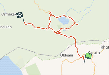
Trail 4x4 of 99 km to be discovered at Arusha. This trail is proposed by vverafon.

Elevation profile

Positioning

Country:
Tanzania, United Republic of
Region :
Arusha
Department/Province :
Karatu District
Municipality :
Gongali
Location:
Unknown
Start:(UTM)
792303 ; 9625762 (36M) S.

Trails nearby

Trail 4x4  - Journée 3 - Photo
4x4
David JACQUET

4x4

, Arusha, , Tanzania, United Republic of
138 km | 172 km-effort
8h 32min
No
Trail Motor  - Ngorongoro Park - Photo
Motor
patjobou

Motor

Very easy
, Arusha, , Tanzania, United Republic of
111 km | 138 km-effort
8h 37min
No


Close
My subscriptions