


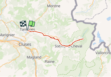
Taninges - Fer à Cheval A/R - 50 km - 750m+

HG74250
User

Length
49 km

Max alt
969 m

Uphill gradient
744 m
Km-Effort
59 km

Min alt
622 m

Downhill gradient
743 m
Boucle
Yes
Creation date :
2020-08-16 07:32:40.057
Updated on :
2020-08-16 16:23:01.355
5h25
Difficulty : Medium

FREE GPS app for hiking
 SityTrail
IGN / Geographical institutes
SityTrail Plus
The world is yours!
About
Trail Mountain bike of 49 km to be discovered at Auvergne-Rhône-Alpes, Upper Savoy, Taninges. This trail is proposed by HG74250.
Positioning
Country:
France
Region :
Auvergne-Rhône-Alpes
Department/Province :
Upper Savoy
Municipality :
Taninges
Location:
Unknown
Start:(Dec)
Start:(UTM)
314022 ; 5108334 (32T) N.
Comments