


Casterino Voie sacrée

psesjs
User
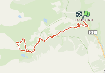

Length
12.6 km

Max alt
2243 m

Uphill gradient
703 m
Km-Effort
22 km

Min alt
1545 m

Downhill gradient
704 m
Boucle
Yes
Creation date :
2020-08-16 08:49:43.357
Updated on :
2020-08-16 14:17:34.978
5h20
Difficulty : Medium

FREE GPS app for hiking
 SityTrail
IGN / Geographical institutes
SityTrail Plus
The world is yours!
About
Trail Walking of 12.6 km to be discovered at Provence-Alpes-Côte d'Azur, Maritime Alps, Tende. This trail is proposed by psesjs.
Description
voie sacrée par itinéraire recommandé par le parc
Photos


Positioning
Country:
France
Region :
Provence-Alpes-Côte d'Azur
Department/Province :
Maritime Alps
Municipality :
Tende
Location:
Unknown
Start:(Dec)
Start:(UTM)
380402 ; 4883877 (32T) N.
Comments