


Chalets de Mayeres

gilbert57
User
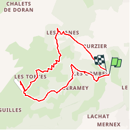

Length
8.5 km

Max alt
1561 m

Uphill gradient
634 m
Km-Effort
16.9 km

Min alt
919 m

Downhill gradient
637 m
Boucle
Yes
Creation date :
2014-12-10 00:00:00.0
Updated on :
2014-12-10 00:00:00.0
3h18
Difficulty : Unknown

FREE GPS app for hiking
 SityTrail
IGN / Geographical institutes
SityTrail Plus
The world is yours!
About
Trail Walking of 8.5 km to be discovered at Auvergne-Rhône-Alpes, Upper Savoy, Sallanches. This trail is proposed by gilbert57.
Description
montée aux chalets depuis le hameau "les Houches"
Positioning
Country:
France
Region :
Auvergne-Rhône-Alpes
Department/Province :
Upper Savoy
Municipality :
Sallanches
Location:
Unknown
Start:(Dec)
Start:(UTM)
315364 ; 5091481 (32T) N.
Comments