


randogps49-192

bubuserge
User
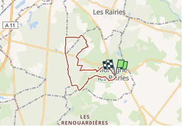

Length
11.3 km

Max alt
49 m

Uphill gradient
92 m
Km-Effort
12.6 km

Min alt
29 m

Downhill gradient
92 m
Boucle
Yes
Creation date :
2020-08-17 16:41:05.767
Updated on :
2020-08-17 16:42:33.805
2h46
Difficulty : Difficult

FREE GPS app for hiking
 SityTrail
IGN / Geographical institutes
SityTrail Plus
The world is yours!
About
Trail Walking of 11.3 km to be discovered at Pays de la Loire, Maine-et-Loire, Montigné-lès-Rairies. This trail is proposed by bubuserge.
Positioning
Country:
France
Region :
Pays de la Loire
Department/Province :
Maine-et-Loire
Municipality :
Montigné-lès-Rairies
Location:
Unknown
Start:(Dec)
Start:(UTM)
710209 ; 5277958 (30T) N.
Comments