


MERCUER La Roche

Michel07
User
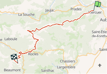

Length
32 km

Max alt
1201 m

Uphill gradient
1362 m
Km-Effort
50 km

Min alt
334 m

Downhill gradient
1215 m
Boucle
No
Creation date :
2020-08-11 04:28:48.0
Updated on :
2020-08-18 17:20:51.632
10h28
Difficulty : Very difficult

FREE GPS app for hiking
 SityTrail
IGN / Geographical institutes
SityTrail Plus
The world is yours!
About
Trail Walking of 32 km to be discovered at Auvergne-Rhône-Alpes, Ardèche, Mercuer. This trail is proposed by Michel07.
Positioning
Country:
France
Region :
Auvergne-Rhône-Alpes
Department/Province :
Ardèche
Municipality :
Mercuer
Location:
Unknown
Start:(Dec)
Start:(UTM)
607634 ; 4943370 (31T) N.
Comments