


Descente de Vauban à Parc de la chappe Ste Catheriy

jmheydorff
User
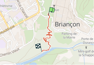

Length
585 m

Max alt
1306 m

Uphill gradient
0 m
Km-Effort
821 m

Min alt
1228 m

Downhill gradient
71 m
Boucle
No
Creation date :
2020-08-19 08:32:00.0
Updated on :
2020-08-19 09:04:30.657
17m
Difficulty : Easy

FREE GPS app for hiking
 SityTrail
IGN / Geographical institutes
SityTrail Plus
The world is yours!
About
Trail Walking of 585 m to be discovered at Provence-Alpes-Côte d'Azur, Hautes-Alpes, Briançon. This trail is proposed by jmheydorff.
Positioning
Country:
France
Region :
Provence-Alpes-Côte d'Azur
Department/Province :
Hautes-Alpes
Municipality :
Briançon
Location:
Unknown
Start:(Dec)
Start:(UTM)
313832 ; 4974424 (32T) N.
Comments