


pont tamarins Valbonne

gillou1947
User
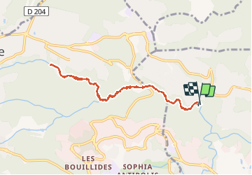

Length
8.4 km

Max alt
170 m

Uphill gradient
129 m
Km-Effort
10.2 km

Min alt
74 m

Downhill gradient
132 m
Boucle
Yes
Creation date :
2020-08-19 08:03:30.257
Updated on :
2020-08-20 06:18:58.448
2h34
Difficulty : Very easy

FREE GPS app for hiking
 SityTrail
IGN / Geographical institutes
SityTrail Plus
The world is yours!
About
Trail Walking of 8.4 km to be discovered at Provence-Alpes-Côte d'Azur, Maritime Alps, Biot. This trail is proposed by gillou1947.
Positioning
Country:
France
Region :
Provence-Alpes-Côte d'Azur
Department/Province :
Maritime Alps
Municipality :
Biot
Location:
Unknown
Start:(Dec)
Start:(UTM)
343722 ; 4832749 (32T) N.
Comments