Trail Walking Saint-Maurice-Navacelles - 
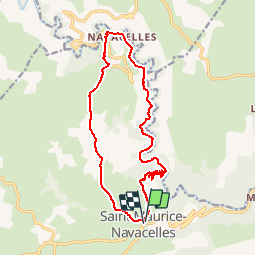
Les Gorges de la Vis - Photo
 ARVIEU
ARVIEU

User

© OpenStreetMap contributors
Length
Length
16.5 km
Max alt
Max alt
624 m
Uphill gradient
Uphill gradient
539 m
Km-Effort
Km-Effort  
24 km
Min alt
Min alt
264 m
Downhill gradient
Downhill gradient
542 m
Boucle
Boucle
Yes
Creation date :
2014-12-10 00:00:00.0
Updated on :
2014-12-10 00:00:00.0

(0 Reviews)

Walking
Walking
5h24
Difficulty : Medium

Scan this QR Code to open this trail in the SityTrail application

FREE GPS app for hiking

Logo SityTrail SityTrail

IGN / Geographical institutes

Download SityTrail from the App Store Download SityTrail from Google Play

Logo SityTrail SityTrail Plus

The world is yours!

Download SityTrail from the App Store Download SityTrail from Google Play Download SityTrail on Huawei AppGallery

About

Trail Walking of 16.5 km to be discovered at Occitania, Hérault, Saint-Maurice-Navacelles. This trail is proposed by ARVIEU.

Description

Saint Maurice de Navacelles, les Gorges de la Vis et retour par le plateau
Accès routier:
par Gignac (75 mn de Montpellier Nord), monter la côte d'Arboras puis à La Vacquerie prendre à droite vers Saint Maurice de Navacelles
par Ganges (90 mn de Montpellier Nord), à Ganges traverser l'Hérault puis direction Madières où on monte vers Saint Maurice de Navacelles

Elevation profile

Positioning

Country:
France
Region :
Occitania
Department/Province :
Hérault
Municipality :
Saint-Maurice-Navacelles
Location:
Unknown
Start:(UTM)
541762 ; 4855152 (31T) N.


Close
My subscriptions